

Québec electoral map
Summary
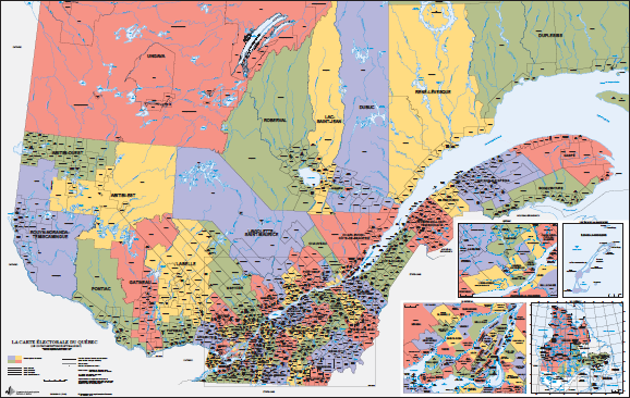
Québec is divided into 125 electoral divisions, which form the provincial electoral map. These electoral divisions are subdivided into electoral precincts and polling subdivisions.
In this section
This page shows the electoral map in effect since 2017. See Electoral map: final boundaries to view the 127 electoral divisions that will be in effect for the next provincial general election.
Interactive map
The interactive map shows Québec’s 17 administrative regions as well as its electoral divisions.
To view the map of an electoral division, begin by selecting one of the administrative regions and then choose the electoral division of your choice from the list given under the regional map. You may then access the information sheet about the electoral division, and its socioeconomic and historical details.
Notes
- The municipal boundaries are the ones that were in effect on January 31, 2017.
- The boundaries of the electoral divisions were simplified on the interactive map.
- The administrative regions boundaries are the ones that were in effect on July 28, 2021
- List of abbreviations used on the electoral maps
Downloadable official maps
Provincial maps
Regional maps
- Abitibi-Témiscamingue (PDF)
- Bas-Saint-Laurent (PDF)
- Capitale-Nationale (PDF)
- Chaudière-Appalaches (PDF)
- Côte-Nord (PDF)
- Estrie–Centre-du-Québec (PDF)
- Gaspésie–Îles-de-la-Madeleine (PDF)
- Île-de-Montréal (PDF)
- Laurentides-Lanaudière (PDF)
- Laval (PDF)
- Mauricie (PDF)
- Montérégie (PDF)
- Nord-du-Québec (PDF)
- Outaouais (PDF)
- Saguenay–Lac-Saint-Jean (PDF)
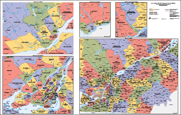
Maps of polling subdivisions and electoral precincts
Electoral division maps are often segmented into several files for easier consultation. They can be divided by municipality or by geographical area (north or south, for example).
A polling subdivision covers a maximum of 475 electors living in a particular area. It is the smallest delimitation unit of an electoral division. Polling subdivisions are numbered sequentially within an electoral division. The territorial boundaries of a polling subdivision may vary from one election to the next. Some residential facilities (CHSLDs, private seniors’ residences, etc.) host a polling station in their common area for electors residing there. Polling subdivision numbers (500, 501, 502, etc.) are assigned to these residential facilities.
An electoral precinct includes all polling subdivisions within a single polling place. An electoral precinct is identified by a circled number.
Finding an electoral division
Use one of the following three methods to select an electoral division and download the polling subdivision maps.